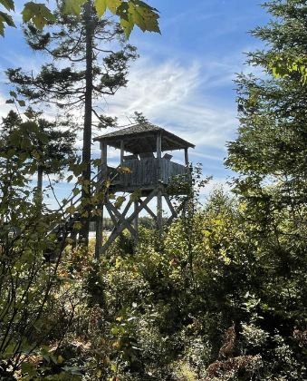
This is a multi-use trail which allows hiking, biking and horse-riding. Bring your own horse for a 6km ride on a shared trail. Climb the 10-meter high viewing tower. Located inland in the Forest Hill Wildlife Management Area (owned by the Island Horse Council) with the railhead located on adjacent property.
The trail is quite convoluted, consisting of clay roads, wide grassy pathways and single woodland paths and a GPS unit is recommended. There are scenic estuary views but it is predominantly mixed forest. Recreationists can do a simple loop in and out but there are many loops and offshoots for those desiring a longer trek. There are plans (2008) for a pathway from the main Forest Hills trails up to the Mount Hope Lookoff. It is a 35 foot high tower with a panoramic view of the region below and information placards installed. A couple of spurs are interesting: one is at Doc’s Marsh where a riverside pathway goes out and back along the stream both ways from the dam area. Another is the Whitlock’s Wildlife Observation Platform trail that is 1 km each way out and back to an estuary over a rooty forest pathway (portions are sometimes damp) to a scenic lookoff platform.
Trail Location: Near Upton just north of Dundas, Kings County
Directions: Take Hwy #4 to # 310. Go North on # 310 1.5 km to 339 then East 1 km to a sign on the north side of the road that says Forest Hills Corral. There is public parking for trucks and trailers and a horse corral. Follow the roadway to the trail that turns into the woods near the corral fencing.
Trail Quick Facts
Difficulty Rating: 3.5
Length: 1.0 – 15.0 km
Structure: Loop
GPS Location: 46 20.815,-62 30.261
Environment: Wilderness
Surface Type: Clay Road
Grass or Vegetation
Forest Floor
Information sourced with permission from Island Trails. www.islandtrails.ca

